What is 'Equivalent Water Thickness'?
The observed monthly changes in gravity are caused by monthly changes in mass. The mass changes can be thought of as concentrated in a very thin layer of water thickness changes near the Earth's surface (i.e., in a layer up to several kilometers thick). In reality, most of the monthly gravity changes are indeed caused by changes in water storage in hydrologic reservoirs, by moving ocean, atmospheric and land ice masses, and by mass exchanges between these Earth system compartments. Their vertical extent is measured in centimeters of equivalent water thickness, much smaller than the radius of the Earth or the horizontal scales of the changes, which are measured in kilometers. Some changes in gravity are caused by mass redistribution in the 'solid' Earth, such as those following a large earthquake, or those due to glacial isostatic adjustment; in those cases, the interpretation of the gravity changes in terms of 'equivalent water thickness' are not correct, even though it is still possible to compute this quantity (i.e., by removing the solid Earth effects to isolate the water-related mass changes).
The mass of the atmosphere is removed during processing using ECMWF atmospheric pressure fields, so the GRACE Tellus surface mass grids do not contain atmospheric mass variability over land or continental ice areas like Greenland and Antarctica (except, of course, for errors in ECMWF). An ocean model is used to remove high frequency (6-hourly to sub-monthly) wind and pressure-driven ocean motions that might otherwise alias into the monthly gravity solutions. The resulting gravity fields would not reflect ocean variability if the model were perfect. To use these results over the oceans, the GRACE Tellus ocean bottom pressure fields have the monthly averaged ocean model grids added back. This is one of the reasons why we provide OCEAN and LAND grids separately. Other reasons include removal of land signals from ocean grids, scaling of land grids, etc.
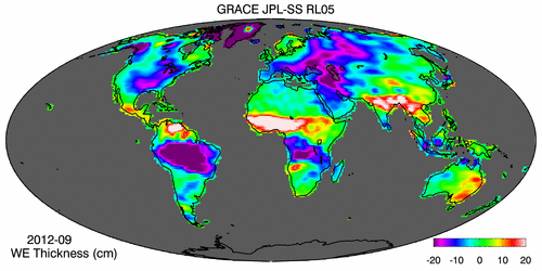
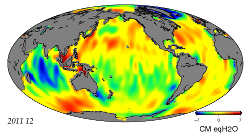
Data available here are changes in equivalent water thickness relative to a time-mean baseline. The basic method is explained in Wahr et al. (1998). The land and ocean grids are processed with different filters that are tuned to best filter out noise while preserving real geophysical signals.
Spherical Harmonic Data Versions
GRACE is a first-of-a-kind mission, so not surprisingly, revisions to the data processing are more frequent than for more mature satellite measurements. Three centers are part of the GRACE Ground System and generate Level-2 data (spherical harmonic fields): CSR (U. Texas / Center for Space Research); GFZ (GeoForschungsZentrum Potsdam); and JPL (Jet Propulsion Laboratory). Their output include spherical harmonic coefficients of the gravity field and of the dealiasing fields used to compute them.
The data we offer here are based on those produced by these data centers (the 'official' releases of the GRACE Project), and have additional, postprocessing steps, summarized in the pages linked to below. Other data centers also offer GRACE-derived mass grids, and they can be found here.
Presently, we provide GRACE-Tellus data from the most recent GRACE gravity fields: Release 05 from CSR, JPL and GFZ. Several tests have shown that RL05 is an improvement over the previous RL04. The RL05 spherical harmonics are used as inputs to our postprocessing steps. We call our OCEAN version from RL05 is 'RL05.DSTvDPC1401' and our LAND version from RL05 is 'RL05.DSTvSCS1401'. The post processing has now been optimized for RL05 spherical harmonics. Notice that these are different version numbers than those we gave to the grids produced soon after RL05 data became available.
Please download ALL MONTHS from these new solutions and discard previous versions in order to work with a consistent time series.
Information and data for OCEAN grids
Information and data for LAND grids
Mascon Data Versions
An alternative to solving for gravity variations in terms of spherical harmonics is to use mass concentration blocks (or “mascons”) as the native basis function. The primary advantage of using mascons as a basis function is that each mascon has a specific known geophysical location (unlike spherical harmonic coefficients which individually have no particualr localization information). We can take advantage of this convenient property to specify apriori information (constraints) during the data inversion to internally remove the correlated error in the gravity solution. So, unlike the RL05 unconstrained spherical harmonic solutions, the constrained mascon solutions typically do not need to be destriped or smoothed. The mascon approach also allows a better separation of land and ocean signals.
Information and data for JPL GLOBAL MASCON grids
Degree 2 / Order 0 Coefficients (Oblateness)
Spherical harmonic coefficients of (degree,order) (2,0) sometimes disagree with those from satellite laser ranging (SLR), which are more reliable. The grids provided here have the (2,0) coefficients replaced by those from SLR. More Information.
Degree 1 Coefficients (Geocenter)
GRACE cannot retrieve spherical harmonic coefficients of degree 1, proportional to the position of the Earth's geocenter relative to an Earth-fixed reference frame. An estimate of these coefficients based on Swenson et al. (2008) is used here. More Information.
Glacial Isostatic Adjustment (a.k.a. Post-Glacial Rebound)
The data provided here have been corrected with a GIA model. Details are described in a separate page. GIA discussion.
Earthquakes
Large earthquakes, such as those off the West Coast of Northern Sumatra (Indonesia) on 12/24/2004; Northern Sumatra on 3/25/2005; Southern Sumatra on 9/12/2007; offshore Maule, Chile on 2/27/2010; and near the East Coast of Honshu, off Tohoku, Japan on 3/11/2011, cause sufficient displacements of the Earth's lithosphere to generate a change in Earth's gravity field that GRACE measures. All the earthquakes mentioned above had magnitudes of 8.5 or higher (https://earthquake.usgs.gov/earthquakes/browse/largest-world.php). It would be incorrect to interpret the changes in gravity they cause as changes in terms of 'equivalent water thickness'. As opposed to the case of Glacial Isostatic Adjustment, for which we have a model good enough to 'correct' the GRACE data with, we have currently NOT corrected the data offered here to remove the signals due to large earthquakes. Users should be wary of signals in the vicinity of these earthquakes. The ocean grids computed by reconstructing the GRACE signals using the EOFs of an ocean model have filtered out most of the earthquakes signals. A user can remove approximately the signal due to an earthquake following the approach of de Linage et al. (2009); see their equation 3.
Destriping and Spatial Smoothing
A source of error, whose telltale signature are N-S stripes is present in the data after the previous steps. Swenson and Wahr (2006) observed a peculiar property of the spherical harmonic coefficients associated with the striping, and designed a class of filters to remove the problem.
The GRACE satellites fly at over 400 km altitude. The gravity field weakens with altitude, and short wavelengths attenuate more than longer ones. As a consequence it is necessary to smooth short wavelengths to recover the set of masses on the Earth surface that cause the gravity field seen by GRACE at its altitude. To reduce this source of noise, a spatial averaging smoother (a Gaussian here) is applied here.
Months with Lower Accuracy
Users need to be aware that the monthly grids have higher errors when the orbit is near exact repeat. Such months include July to December 2004, and Jan & Feb 2015. Another source of larger errors is a lack of data in a particular month.
Data Gaps Since 2011
Active 'battery management' started in 2011 due to the aging batteries on the GRACE satellites. During certain orbit periods over several consecutive weeks, no ranging data are collected and hence no gravity fields can be computed. These gaps occur approximately every 5-6 months, and last for 4-5 weeks (also see 'GRACE months' for a complete list of data months & outages).
References
Chambers, D.P. and J.A. Bonin: Evaluation of Release 05 time-variable gravity coefficients over the ocean. Ocean Science 8, 859-868, 2012. www.ocean-sci.net/8/859/2012.
Chambers, D. P: Observing seasonal steric sea level variations with GRACE and satellite altimetry, J. Geophys. Res., 111 (C3), C03010, 10.1029/2005JC002914, 2006.
Cheng, M. and Tapley, B.D.: Variations in the Earth's oblateness during the past 28 years, J. Geophys Res v109, B9, 2004.
de Linage C., L. Rivera, J. Hinderer, J.-P. Boy, Y. Rogister, S. Lambotte and R. Biancale: Separation of coseismic and postseismic gravity changes for the 2004 Sumatra–Andaman earthquake from 4.6 yr of GRACE observations and modelling of the coseismic change by normal-modes summation. Geophys. J. Int. (2009) 176, 695–714, doi: 10.1111/j.1365-246X.2008.04025.x.
Swenson, S. C. and J. Wahr, Post-processing removal of correlated errors in GRACE data, Geophys. Res. Lett., 33, L08402, doi:10.1029/2005GL025285, 2006.
Swenson S.C , D. P. Chambers, and J. Wahr: Estimating geocenter variations from a combination of GRACE and ocean model output. J Geophys. Res.-Solid Earth, Vol 113, Issue: B8, Article B08410. 2008.
Wahr, J., M. Molenaar, and F. Bryan, Time-variability of the Earth's gravity field: Hydrological and oceanic effects and their possible detection using GRACE, J. Geophys. Res., 103, 32,20530,229, 1998.