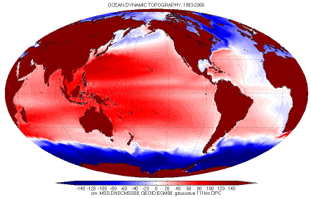
The mean dynamic ocean topography (DOT) is the difference between the time-averaged sea surface and the geoid (the equipotential surface of the Earth's gravity field that best fits the mean sea surface). All geoid slopes are 'horizontal'. A tilt of the the sea surface relative to the horizontal measures the strength of surface 'geostrophic' currents. The mean DOT (MDOT) measures the long-term-averaged strength of ocean currents, the 'steady-state' circulation. One example is the Gulf Stream, whose position averaged over any one year now is about the same as in 1786, when Benjamin Franklin and Timothy Folger charted it (Richardson, 1980). The North-South (meridional) gradient of the DOT is proportional to the East-West (zonal) geostrophic component of ocean surface current velocities (the rest is the wind-driven Ekman current); the zonal gradient of the DOT is proportional to the meridional velocity.
The DOT can be constructed from geodetic data: an altimetric mean sea surface (from nearly 2 decades of radar altimetry), and an accurate geoid (Bingham et al, 2011).
The DOT can also be constructed by combining in-situ oceanographic data (temperature and salinity of seawater, direct measurements of current velocity, etc) (Niiler et al, 2003). A third way is by combining the geodetic estimate (altimetry minus geoid) with the traditional oceanographic estimate (Maximenko et al, 2009; Rio et al, 2011).
The most up-to-date and accurate MDOTs are computed using data from ESA's GOCE satellite (e.g., Bingham et al, 2011), sometimes in combination with GRACE data. An MDOT computed with GOCE data can be constructed using the very useful GOCE User Toolbox (GUT).
For up-to-date MDT data and derived products, as well as more detailed information, please visit either DTU's or AVISO's websites.


Acknowledegment and Citation
Tapley B.D., D.P. Chambers, S. Bettadpur and J.C. Ries, 2003: Large scale ocean circulation from the GRACE GGM01 Geoid. Geophys. Res. Letters 30 (22): doi:10.1029/2003GL018622.
References
Andersen, O. B., and P. Knudsen (2009), DNSC08 mean sea surface and mean dynamic topography models, J. Geophys. Res., 114, C11001, doi:10.1029/2008JC005179.
Bingham, R. J., P. Knudsen, O. Andersen, and R. Pail (2011), An initial estimate of the North Atlantic steady?state geostrophic circulation from GOCE, Geophys. Res. Lett., 38, L01606, doi:10.1029/2010GL045633.
Chambers (2004): Powerpoint presentation (2.15 MB) presents an earlier version of this work, using earlier MSS and Geoid estimates.
Maximenko, Niiler et al (2009) Mean dynamic topography of the ocean derived from satellite and drifting buoy data using three different techniques. J. Atmospheric and Oceanic Technology 26, pp 1910-1919.
Niiler, P. P., N. A. Maximenko, and J. C.McWilliams (2003): Dynamically balanced absolute sea level of the global ocean derived from near-surface velocity observations, Geophys. Res. Lett., 30(22), 2164, doi: 10.1029/2003GL018628.
Pavlis, N. K., S. A. Holmes, S. C. Kenyon, and J. K. Factor (2012), The development and evaluation of the Earth Gravitational Model 2008 (EGM2008), J.Geophys.Res., 117, B04406, doi:10.1029/2011JB008916.
Richardson, P.L. (1980): The Benjamin Franklin and Timothy Folger Charts of the Gulf Stream, In: Oceanography, the Past, edited by M. Sears and D. Merriman. Springer Verlag, Inc, NY.
Rio, M. H., S. Guinehut, and G. Larnicol (2011), New CNES?CLS09 global mean dynamic topography computed from the combination of GRACE data, altimetry, and in situ measurements, J. Geophys. Res., 116, C07018, doi:10.1029/2010JC006505